Regional Profile
The NJTPA Region—Key Facts
Composed of
- Thirteen counties; Bergen, Essex, Hudson, Hunterdon, Middlesex, Monmouth, Morris, Ocean, Passaic, Somerset, Sussex, Union, and Warren
- The state’s two largest cities, Newark and Jersey City
- 384 municipalities
- 4,200 square miles, over half of the state’s land area
population/jobs
- 7 million people (2022 Census ACS) and over 3.4 million payroll jobs (2022)
- 51% minority (2022 ACS)
- 22% under 18 years old; 61% 18-64; 17% 65+
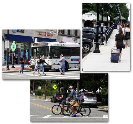
transportation system
- 26,000 miles of roads: 2,300 state, 3,700 county, and 20,000 municipal
- NJ Transit bus: 250 local and express bus routes—carrying 353 million trips annually
- NJ Transits rail: 10 commuter rail lines with 150 stations and 390 miles of track and 2 light rail lines with 41 stations and 23 miles of track
- Amtrak: intercity service from Metropark, New Brunswick, Newark Penn Station, Newark International Airport
- PATH: 14-mile PATH commuter rail service connecting Lower and Midtown Manhattan
- 4,900 bridges
- Three ferry companies operating up to 18 routes between New Jersey and New York City
- Freight: the second largest container port in the US; trucking industry handling 78% of freight tons
- Newark Liberty International Airport: over 43 million passengers and nearly 750,000 tons of air cargo in 2022
- Over 200 miles of paths and trails shared by bicyclists and pedestrians
COMMUTING
(2022, excluding work from home):
- Single occupant vehicle 59% (vs. 69% national average)
- Carpool 8% (vs. 9% national average)
- By transit 10% (vs. 3% national average)
- By foot 3% (vs. 2% national average)
ALSO SEE: city/county subregional profiles.