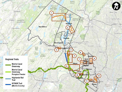
Passaic County’s first bicycle master plan provides guidelines and standards on the types of facilities and detailed recommendations for a dozen locations that would create an expansive network of bike lanes spanning all 16 municipalities.
Andras Holzmann, supervising planner for the Passaic County Department of Planning, presented an overview of BIKE Passaic County to the NJTPA’s Regional Transportation Advisory Committee during its June 13 meeting. The study was completed through the NJTPA’s Subregional Studies Program, a competitive grant program open to the 13 counties and two cities on the NJTPA Board.
 With an area of nearly 200 square miles, Passaic County features a diverse geography, ranging from urban areas in the south, like the county seat of Paterson, its largest city, to rural areas in the north. The plan looked at areas that could connect to trails and future trails, such as the Morris Canal Greenway, Highlands Rail Trail, and NYS&W Trail in Morris County that briefly veers into Wayne, as well as to commercial corridors, downtowns and transit, according to Holzmann.
The plan presents detailed recommendations, called concept level plans, for each of the following locations:
- West Milford Connection to Highlands Rail Trail, West Milford and Ringwood
- Ringwood Connection to Highlands Rail Trail, Ringwood
- Main Street Complete Street, Bloomingdale
- Morris Canal Greenway Connection, Wayne
- Black Oak Ridge Connections to Morris Canal Greenway, Wayne
- Parish Drive Connections to Morris Canal Greenway, Wayne
- Wayne-Haledon Community Connection, Wayne and Haledon
- High Mountain Road Connection to Nature Preserve, North Haledon
- Hawthorne North-South Connection, Hawthorne
- McBride Avenue, Woodland Park
- Clifton Avenue, Clifton
- Passaic-Clifton Community Connection, Passaic and Clifton
The plans include overviews of each location, maps, proposed improvements, and the level of difficulty to implement.
These preliminary concepts aim to build support for potential improvements and assist in developing funding and grant applications for design work and construction.
The study also resulted in the creation of a Pattern Book, which will serve as a design guide that includes standards for creating on- and off-road bike lanes, shared roads, pavement markings and more.
The master plan aims to increase safety and comfort, enhance access and mobility, inspire collaboration and coordination between government agencies and departments, and build community support for bicycling, and support economic, health, resiliency, and sustainability efforts.
The plan also makes planning and policy recommendations including:
- Establishing a bicycle/pedestrian or Complete Streets Advisory Committee with the responsibility of advising municipal staff and boards on bicycle projects and needs.
- Creating opportunities for people in Passaic County to borrow or purchase bikes, e-bikes, and tools at low or no cost.
- Engaging local groups to develop and implement an Open Streets event.
- Developing a plan for bicycle wayfinding signage.
 Holzmann said during the study some communities raised concerns about removing parking spaces to add bike lanes. The design guide presents some solutions, such as “hybrid streets,” which use a parallel network of bike lanes without impacting parking in tight urban areas, so if there are bike lanes in one direction on one street, they go in the other direction on another street. He said there are other potential options that could also be explored. “It’s something that we have to go into further detail about with those municipalities.”
Once the final report is completed it will be shared on the study webpage.