October 2022
Posted: 10/27/2022 3:35:21 PM
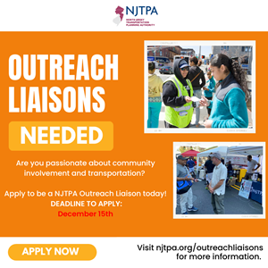
The NJTPA is recruiting community members to participate in its pilot Outreach Liaison Program, which launched last year. The deadline to apply is December 15.
Outreach liaisons serve as trusted advocates who help engage members of their communities in the NJTPA's projects and programs. Residents of the NJTPA's 13-county region are eligible to apply. Outreach liaisons work with the NJTPA to tailor the agency’s public outreach strategies to the specific needs of communities in the region.
The purpose of the Outreach Liaison Program is to increase diversity, inclusion and participation of underrepresented racial, ethnic, and cultural groups in the NJTPA’s transportation planning work. Potential activities could include attending community events on behalf of the NJTPA, distributing information about projects or public surveys, planning and hosting community conversations, or sharing information through social media and other online networks. Outreach liaisons have also provided translation services.
Outreach liaisons have helped engage the public in the creation of a regional Active Transportation Plan, which aims to establish a safe and functional regional network of pedestrian and bicycle facilities to better connect where people live to where they need to go
Ideal candidates are members of grassroots networks who are passionate about community involvement, particularly engaging traditionally underrepresented communities. Through this program, participants gain skills in networking, communication, event planning, meeting facilitation, and outreach and engagement techniques. More importantly, they provide the NJTPA with valuable insights for our projects and programs. Participants are paid a stipend for their time.
The NJTPA is developing the pilot Outreach Liaison Program with support from the Public Outreach and Engagement Team at the Voorhees Transportation Center at Rutgers University. To learn more about the program or apply, visit njtpa.org/OutreachLiaisons.
Posted: 10/26/2022 10:18:49 AM
Work to create a continuous greenway along the former Morris Canal continues, with individual projects approaching major milestones.
Joe Macasek and Tim Roth of the Canal Society of New Jersey presented updates on various greenway projects during the Morris Canal Working Group meeting October 20. The NJTPA coordinates the working group.
"The key words are patience and perseverance,” Macasek said. “These projects are complicated and always take longer than you think.”
Work on the Lock Tenders House in Wharton is nearing completion, Macasek said. The Borough of Wharton held a ribbon cutting in August to celebrate the restoration of Lock 2 East and work on the house, which will serve as a museum.
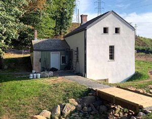 Interior work in the Lock Tenders House progressed in October, with new floorboards, walls and windows. “This is a wonderful project reproducing a 200-year-old building with modern building codes and appropriate compromises to bring to fruition,” he said.
The lock has been reconstructed and there are plans to have a drop gate installed soon, which would enable the water level to be raised and lowered as it was when the canal was active, Macasek said.
Meanwhile, the Boonton Greenway Trail portion of the greenway could see the next significant milestones by next year. Macasek said the Town of Boonton plans to complete its trail in four phases and will connect the greenway with several local history sites and natural assets.
“We envision a greenway that has many branches and many stories,” he said.
Boonton is securing a contract for the Arch Bridge stabilization, with the goal of construction starting in the spring. Macasek said the railroad trestle, which is planned to be a public walkway, is in the engineering assessment phase. Acquisition of the railroad turntable on the other end of river is in negotiations with NJ TRANSIT. Stone arches that were part of the blast furnace complex will be saved and interpreted, he added.
Some of these projects, including the restoration work in Wharton, have been funded through the Transportation Alternatives Program, a competitive grant awarded by the New Jersey Department of Transportation in partnership with the NJTPA. Applications for the next round of funding are due November 3.
Sascha Frimpong, director of local project development at the NJTPA, gave an update on several other projects being funded through prior rounds of grant funding. This includes:
-
Peckman Crossing in Little Falls, Passaic County: New pedestrian bridge to be constructed over the Peckman River, with a path leading to bridge on either side that ties into existing Greenway trail, $1.47 million.
-
Jersey City Morris Canal Greenway, Hudson County: Five of 14 canal segments to be funded, $5.2 million.
-
The Pompton Feeder, Passaic County: This project, which is in the design phase, would create an additional eight miles of primarily off-road trails along the former Pompton Feeder of the canal, using almost six miles of NJ District Water Supply Commissions right of way, $3 million.
-
Trail construction, Warren County: This project, which is in the design phase, will include seven greenway segments, $1.6 million.
-
Waterloo Village Restoration Project, Sussex County: This project, which is in the design phase, will restore three Morris Canal-related historic buildings, Seymor R. Smith House, Waterloo Hotel, and Tenant House, $3 million.
Hackensack River Greenway
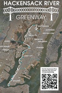 In addition to the Morris Canal Greenway updates, Sam Schroeder, a principal planner with Hudson County, gave an overview of plans to create the Hackensack River Greenway, which is also being coordinated through a working group. Hudson County adopted the Hackensack River Greenway Plan in February.
The greenway in its current state is a series of segments that have been developed by municipalities or the county. The working group is identifying key connections to create a continuous greenway from Bayonne through Jersey City and Secaucus and into North Bergen.
“We envision public access along the entirety of the waterfront,” Schroeder said, adding the new greenway would connect to others in the area, including the Hudson-Essex Greenway and the Morris Canal Greenway.
Posted: 10/21/2022 12:03:40 PM
Portions of two state highways in New Brunswick are being equipped with technology that will collect data and help researchers improve safety and test out an autonomous shuttle.
Rutgers University — in partnership with Middlesex County, the New Jersey Department of Transportation, the City of New Brunswick, and the New Jersey Economic Development Authority — is deploying the technology as part of the DataCity Smart Mobility Testing Ground along portions of Route 27 and Route 18, a network of 14 sensors along a 2.4-mile corridor through downtown New Brunswick.
“The idea there is to make our transportation system safer and more efficient,” said Peter Jin, an associate professor at the Rutgers Center for Advanced Infrastructure and Transportation (CAIT). He gave a presentation on the project during the joint meeting of the Planning and Economic Development and Project Prioritization committees October 17.
The social cost of replacing personal vehicles with self-driving ones remains too high to be practical, Jin said. Cities instead are exploring driverless shared-ride shuttles, including New Brunswick, which is working with Verizon’s autonomous shuttle program. He explained that the testing site would help make the infrastructure smarter, by using sensor technology similar to that used in driverless cars to determine where there are safety conflicts between pedestrians and vehicles, for example. The roadside sensors can gather significantly more data than vehicle sensors, including the location of people, other vehicles and structures.
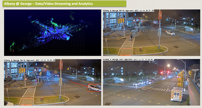 The first sensor was installed at Albany and George streets in September 2021. As of this summer there were five intersections, mostly along Route 27, equipped with the technology and by March 2023 the goal is to have 10 up and running with full data sharing and testing services. Jin said the Roadside Edge Living Lab is expected to launch in November. That technology can help pinpoint where there are near-misses, generating a map of where pedestrian and vehicle conflicts occur.
While “connected vehicle” technology under development communicates and sends alerts from sensor to vehicle, or vehicle to vehicle, Jin said the test site also connects to a smartphone app, which would enable road users who aren’t in a vehicle, like pedestrians to cyclists, to have access to it.
“Crashes are a very rare event, but near-miss conflicts happen almost every day,” Jin said. “We can use near-miss information to identify locations to improve traffic safety or deploy a safety alert system.”
Jin said the project is already gathering huge amounts of data. If the site relied only on sensors on a test vehicle, like Google’s self-driving car project Waymo, there would be far less data.
"We hope to use this [data] as a way to fill a critical industry data void,” he said, noting that more than 70 percent of data used to train self-driving models are generated from simulations.
Rutgers CAIT's testing ground is part of a collaboration led by Columbia University that was recently awarded a $26-million, five-year grant from the National Science Foundation to establish a new Gen-4 NSF Engineering Research Center for Smart Streetscapes.
The research center’s mission is to employ roadside smart units and infrastructure as the basis to deploy the rapidly growing self-driving technology.
“If we can have full coverage of the entire corridor, we can essentially form our dataset and recreate this type of vehicle-based dataset for every single vehicle passing through the testing ground,” Jin said.
Posted: 10/20/2022 12:05:44 PM
New Jersey’s location in proximity to New York City and within a short drive of millions of consumers makes it a prime location for warehousing and logistics for an e-commerce industry that has boomed since the pandemic. Municipalities around the state, however, are grappling with where to put proposed distribution and fulfillment centers.
Donna Rendeiro, executive director of the New Jersey Office of Planning Advocacy, and Wilda Diaz, former mayor of Perth Amboy in Middlesex County, presented on the issue during the October 17 Freight Initiatives Committee meeting.
The state recently issued guidance to help municipalities determine how, or whether, to allow warehouses. Planning and zoning boards around the state have been inundated in recent years with applications to build giant warehouses, distribution and fulfillment centers.
 “The guidance we’ve put together does acknowledge the importance of the logistics industry," Rendeiro said, noting that warehousing and logistics accounts for about 12 percent of New Jersey’s employment – about one in eight jobs. “It really is critical to our economic sustainability. However, because the market is so robust right now, there’s a lot of pressure on the municipalities and we must make sure that this development is done by right sizing and right locating so that we don’t negatively impact our environmental resources and our infrastructure,” she said.
Warehouse developers have historically favored locations with access to the port but over the past decade that need and market desire has pushed development into farmland, according to Rendeiro, and that’s added to the stress of environmentally sensitive areas.
A number of municipalities and counties asked the state to help determine what their land use practices should be. “We don’t encourage [state] legislation because we do understand home rule; it’s a locally driven process but we think it’s important to provide this guidance," Rendeiro said.
The state’s guidelines encourage a proactive rather than reactive approach, providing municipalities factors to consider when developing or updating their master plan and ordinances. The guidelines also support a regional approach to siting warehouses, she said. “A proactive approach allows for municipalities to control their own destiny.”
Rendeiro pointed to the state’s Local Redevelopment and Housing Law as an important tool in redeveloping brownfields, which are underutilized, and often contaminated, former industrial sites. She called it “a phenomenal law” that gives eligible municipalities the ability to work with a developer to negotiate off-site improvements that they might not otherwise be able to require.
Former industrial sites throughout Perth Amboy that once employed thousands left the city with a legacy of contamination that was unaddressed for many years. Diaz credited the city with having a vision early-on to address the sites by creating the Perth Amboy Redevelopment Agency (PARA) in 1997 – an agency she chaired -- and adopting a redevelopment plan.
 One of the projects to come out of that plan is a Home Depot distribution center, which Diaz said has changed the community. The project invested $500 million for new construction and more than $10 million to remediate 92 acres of contaminated land at a former industrial site, opening a logistics center that created more than 500 jobs. In negotiations, the city was able to acquire open land and had a developer construct an amphitheater as well as major road repairs, infrastructure improvements and other enhancements.
More than 500 acres of contaminated sites in Perth Amboy have been remediated, which attracted and generated nearly $1 billion of new construction projects, implementing $25 million in infrastructure improvements, generating almost $15 million in tax ratables and more than 3,000 new jobs for local residents, Diaz said.
“At the end of the day, residents want to live and work in their community,” Diaz said adding that residents are happy to see the abandoned sites in use again. She said many people remembered “someone in their family who worked in those industrial sites, so we knew how important it has been for our community.”
Posted: 10/14/2022 1:16:34 PM
If you’ve ever driven past an electronic sign that doesn’t always flash your speed in miles per hour (mph), don’t assume that it’s not collecting your data.
goHunterdon, the Transportation Management Association (TMA) for Hunterdon County, partners with municipalities that request to use its speed monitoring program and studies locations for a month – the first two weeks operate in “stealth” mode, followed by two weeks in “display” mode.
 “It’s funny because we always talk about how many residents or people from town tell us that the sign isn’t working, it’s off. That’s what we’re looking for, we’re looking for stealth data,” Ryan Fisher, goHunterdon’s safety programs manager, said. Fisher and Executive Director Tara Shepherd briefed members of The NJTPA’s Regional Transportation Advisory Committee (RTAC) about the speed monitoring program during their October 12 meeting.
“Vehicle speed is one of the most important factors in crash severity,” Peter Bilton, Principal Planner, TMA & Mobility Programs, at NJTPA, said. “The risk of serious injury and death increases with increase in vehicle speeds and that’s why safe speeds is one of the five components of the Federal Highway Administration’s Safe Systems approach.”
In 2020, speeding deaths represented 29 percent of all traffic fatalities, up from 26 percent in 2019, according to the National Highway Traffic Safety Administration (NHTSA).
goHunterdon started its speed monitoring program about 10 years ago as a loan program, in which municipalities could borrow a radar unit. It has since evolved into a more formalized program, with 73 studies conducted for municipalities, many of which asked for multiple studies, according to Shepherd.
Flemington-based goHunterdon is among four TMAs with speed study units. The others (Avenues in Motion, Greater Mercer TMA, and Ridewise) typically use their speed study programs to evaluate the effectiveness of the messaging of the StreetSmart NJ campaign, Shepherd said, adding that goHunterdon is the only TMA providing speed studies for municipalities.
.png.aspx?width=135&height=100 "goHunterdon-speed-report-peds-crossing-(1).png") goHunterdon’s program was started based on feedback from partner municipalities that would get resident complaints or concerns about speeding on local roads. The program allows municipalities to collect objective data but also prioritize enforcement locations and times, Shepherd said. The signs, when displaying speeds, can also assist municipalities interested in a traffic-calming mechanism.
goHunterdon’s program was started based on feedback from partner municipalities that would get resident complaints or concerns about speeding on local roads. The program allows municipalities to collect objective data but also prioritize enforcement locations and times, Shepherd said. The signs, when displaying speeds, can also assist municipalities interested in a traffic-calming mechanism.
An online application for the program typically is completed by someone from the police department or the clerk or mayor. Once the municipality installs a metal post at the preferred location, goHunterdon will install one of two available signs, one an 11-inch display and the other 12 inches. The 20-pound unit runs $3,000 to $4,000 and includes a one-year cloud data subscription that costs $400 annually after the first year, Shepherd said. goHunterdon received a grant from the New Jersey Division of Highway Traffic Safety to purchase the units and software.
 Studies run for one month – the first two weeks in stealth mode, followed by two weeks in display mode. In stealth mode, the unit appears off but collects data and in display mode it will flash and show vehicle speeds. goHunterdon then generates a report that examines average speed and 85th percentile speed. “There isn’t always a problem,” Fisher said, citing an example of a study of a 25 mph zone that showed average speed of 15 mph and 85th percentile speed of 22 mph.
“Residents might feel that cars are speeding but this alleviates concerns from some residents,” Fisher said. When there is speeding, the data could suggest what time a patrol car should be in that location. The units also are used for vehicle counts, which can be helpful to local police when examining construction projects to see how a road is affected by traffic volume.
“Most of the communities that we were work with are looking at this in a comprehensive way and this is just another data point that they use in those conversations. We have provided speed study information to consultants that have prepared applications for different infrastructure funds,” Shepherd said. “We’ve done a lot of studies around schools and developing school traveling plans, things like that. Each municipality’s a little different how they use it but they’re all very appreciative of it.”