Portions of two state highways in New Brunswick are being equipped with technology that will collect data and help researchers improve safety and test out an autonomous shuttle.
Rutgers University — in partnership with Middlesex County, the New Jersey Department of Transportation, the City of New Brunswick, and the New Jersey Economic Development Authority — is deploying the technology as part of the DataCity Smart Mobility Testing Ground along portions of Route 27 and Route 18, a network of 14 sensors along a 2.4-mile corridor through downtown New Brunswick.
“The idea there is to make our transportation system safer and more efficient,” said Peter Jin, an associate professor at the Rutgers Center for Advanced Infrastructure and Transportation (CAIT). He gave a presentation on the project during the joint meeting of the Planning and Economic Development and Project Prioritization committees October 17.
The social cost of replacing personal vehicles with self-driving ones remains too high to be practical, Jin said. Cities instead are exploring driverless shared-ride shuttles, including New Brunswick, which is working with Verizon’s autonomous shuttle program. He explained that the testing site would help make the infrastructure smarter, by using sensor technology similar to that used in driverless cars to determine where there are safety conflicts between pedestrians and vehicles, for example. The roadside sensors can gather significantly more data than vehicle sensors, including the location of people, other vehicles and structures.
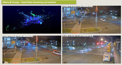 The first sensor was installed at Albany and George streets in September 2021. As of this summer there were five intersections, mostly along Route 27, equipped with the technology and by March 2023 the goal is to have 10 up and running with full data sharing and testing services. Jin said the Roadside Edge Living Lab is expected to launch in November. That technology can help pinpoint where there are near-misses, generating a map of where pedestrian and vehicle conflicts occur.
While “connected vehicle” technology under development communicates and sends alerts from sensor to vehicle, or vehicle to vehicle, Jin said the test site also connects to a smartphone app, which would enable road users who aren’t in a vehicle, like pedestrians to cyclists, to have access to it.
“Crashes are a very rare event, but near-miss conflicts happen almost every day,” Jin said. “We can use near-miss information to identify locations to improve traffic safety or deploy a safety alert system.”
Jin said the project is already gathering huge amounts of data. If the site relied only on sensors on a test vehicle, like Google’s self-driving car project Waymo, there would be far less data.
"We hope to use this [data] as a way to fill a critical industry data void,” he said, noting that more than 70 percent of data used to train self-driving models are generated from simulations.
Rutgers CAIT's testing ground is part of a collaboration led by Columbia University that was recently awarded a $26-million, five-year grant from the National Science Foundation to establish a new Gen-4 NSF Engineering Research Center for Smart Streetscapes.
The research center’s mission is to employ roadside smart units and infrastructure as the basis to deploy the rapidly growing self-driving technology.
“If we can have full coverage of the entire corridor, we can essentially form our dataset and recreate this type of vehicle-based dataset for every single vehicle passing through the testing ground,” Jin said.