July 2023
Posted: 7/18/2023 12:41:23 PM
 The New Jersey Chapter of the American Society of Landscape Architects has recognized the Main Avenue Local Concept Development Study in the City of Passaic with a Merit Award.
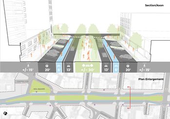
The award was given to Passaic County, the City of Passaic, the North Jersey Transportation Planning Authority (NJTPA) and consultants Arterial and Sam Schwartz. The study, completed in 2021, was led by Passaic County in partnership with the City of Passaic, with funding from the NJTPA’s Local Capital Project Delivery Program. It explored ways to improve travel safety, traffic flow, access to transit, walkability and support economic development along the corridor from Monroe Street to Gregory Street. The study recommends converting a parking area in the middle of the corridor into green space.
“We’re honored to have the Main Avenue study recognized. This project is a great example of how counties and cities can work together with the NJTPA to use federal dollars to plan local infrastructure improvements,” said Passaic County Commissioner John W. Bartlett, Chair of the NJTPA Board of Trustees. “The vision this study presents will improve safety while supporting the local economy, which are goals of the NJTPA’s long-range transportation plan. Add in other initiatives, like new parks funded by state Green Acres and county Open Space funds, plus support and funding for businesses and schools, and studies like this one can catalyze the transformation of a community.”
Passaic City Mayor Hector Lora said, “Once this project is eventually completed it will be a game changer for our downtown business district. It will create a sense of place for visitors from all around.”
Concept development is the first phase of work in the Local Capital Project Delivery Program. Concept development studies review existing conditions and needs, and identify possible solutions to address them. Completing this initial phase of work allows the county to seek federal funding for additional work, including preliminary engineering and eventually construction.
The study included extensive public engagement. When the COVID-19 pandemic affected the ability to hold in-person meetings, they were shifted to virtual events, including a Facebook Live hosted by Mayor Lora.
“Transparency and community involvement are at the cornerstone of my administration. After I hosted multiple virtual and in-person meetings with residents and stakeholders, they recommended converting the parking area in the middle of Main Avenue into a promenade and adding reverse angle parking adjacent to the businesses, which was incorporated into the study,” Mayor Lora said.
The promenade would have shade trees, plantings, a walkway, and seating. This concept includes bicycle lanes and would reduce the road from two travel lanes in each direction to one to shorten the crossing distance for pedestrians. The study also recommends converting the intersection of Main Avenue, Pennington Avenue, State Street and River Drive into a modern roundabout to improve safety and the flow of traffic.
The project is expected to advance to the preliminary engineering phase when the NJTPA Board of Trustees votes on a new Transportation Improvement Program in September.
Posted: 7/17/2023 9:00:00 AM
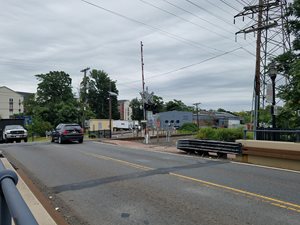 Somerset County and the NJTPA recently completed a study that explored ways to eliminate an at-grade rail crossing on South Main Street in Bound Brook.
The Port Reading Secondary Line crosses South Main Street at-grade. Conrail Shared Asset Operations owns and operates the line, which extends 16 miles from a junction with the Lehigh Line west of South Main Street to Port Reading on the Arthur Kill.
Up to six round-trip trains, with up to 100 railcars, use the line each day. It typically takes about 3 minutes for the trains to cross South Main Street, causing traffic to back up into Bound Brook, South Bound Brook and Middlesex Borough. During peak traffic hours, this can cause vehicle delays of 15 to 20 minutes. The nearby Raritan Valley Line and Lehigh Line cross the road on elevated rail bridges.
This project was conducted through the NJTPA’s Freight Concept Development Program. Concept development studies explore different options for addressing a problem and culminate in the selection of a preliminary preferred alternative, which can be advanced to preliminary engineering for further refinement, and then eventually construction. Stakeholders and the public are engaged to help establish which needs the study should address and consider the various options. These studies also consider any impacts the project could have on the environment, cultural resources, and Environmental Justice communities.
Fourteen different options were developed and evaluated as part of this study. Some of the options were dismissed because they would encroach on existing businesses or the Old Stone Arch Bridge, a historic structure near the rail line. The study also briefly explored whether the road could be rerouted below the rail line, however this was not possible due to the water elevation of the adjacent Raritan River.
The preferred option recommends adding new track parallel to the Lehigh Line. A new bridge would be built to carry this track over South Main Street. This alignment also calls for new railroad bridges over the Green Brook and over River Road in Middlesex Borough as the new alignment reconnects to the existing Port Reading Secondary line. The study estimates the project would cost $53.7 million. This includes acquiring right-of-way, environmental remediation, engineering, relocating utilities and construction.
While the at-grade crossing is in Bound Brook, the study would include moving track in neighboring Middlesex Borough.
This study can be used to seek grant funding to advance the project.
Posted: 7/13/2023 10:11:28 AM
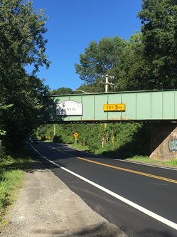 Morris County and the NJTPA recently completed a study that explored ways to improve truck movements and safety along Berkshire Valley Road in Roxbury Township.
The study aimed to address two problems: a vertical clearance restriction created by the Chester Branch Bridge and a severe angle at the intersection of North Dell Avenue and Berkshire Valley Road. Several trucks have struck the bridge in recent years, damaging the structure and interfering with rail operations and impacting roadway operations while the bridge was repaired. The 22 degree angle of the intersection at North Dell Avenue makes it difficult for trucks to navigate.
This project was conducted through the NJTPA’s Freight Concept Development Program. Concept development studies explore different options for addressing a problem and culminate in the selection of a preliminary preferred alternative, which can be advanced to preliminary engineering for further refinement, and then eventually construction. Stakeholders and the public are engaged to help establish which needs the study should address and consider the various options. These studies also consider any impacts the project could have on the environment, cultural resources, and Environmental Justice communities.
This study recommended using accelerated bridge construction techniques to fully replace the Chester Branch Bridge. The new bridge would be taller to allow trucks to safely pass underneath. Precast concrete components would be used, which would allow for the bridge to be fully replaced in about two weeks. This would require a short closure of rail service during construction. The estimated cost is $6.6 million.
The study also recommends realigning the intersection of North Dell Avenue and Berkshire Valley Road creating a four-legged intersection with Old Timber Court. The lanes at the intersection would be widened to 50 feet to accommodate truck turning movements. This option would result in a net reduction of about 11,000 square feet of impervious pavement. The estimated cost is $632,000.
Morris County can use this study to seek funding for future phases of work for both projects.
Posted: 7/12/2023 1:22:10 PM
Something as simple as painting a crosswalk or putting up a stop sign might not seem like it matters very much in the scheme of things. But Passaic City Mayor Hector Lora told NJTPA Board members the simple changes can make a significant impact, noting his city has gone two years without a fatality caused by a vehicle crash.
“It matters to the lives of those families and those children and individuals that by necessity have to be out there, not because they want to,” he said. “Some of us have the luxury of strolling through the streets and the sidewalks and riding our bikes because of recreation or fitness, but others, unless they’re on a bike, they can’t get to work.”
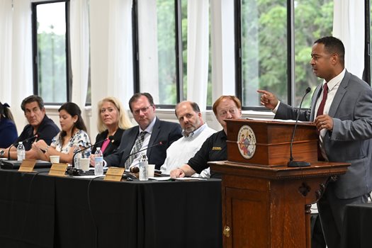 Lora highlighted the collaborations between public agencies during his featured presentation, “How Transportation & Redevelopment are Coming Together to Better Prepare Passaic for the Future,” at the July 10 Board meeting at the Great Falls Center in Paterson. The City of Passaic has benefited from several NJTPA-funded projects, and he thanked the Board for its support.
“The work you do is noble,” he said. “Noble not just because it can get recognized and printed and we give each other plaques and awards, but because real lives are impacted.”
In communities where vehicle ownership is low, safety measures that can be taken for granted elsewhere are critical. He said people expect there to be usable sidewalks and visible crosswalks for children to use to get to school safely.
“For me, as a mayor of an urban community that sometimes is the victims of unsafe conditions, it’s the difference between a mother with her baby carriage having to walk on the streets with traffic flying by or navigating her journey on a widened sidewalk,” he said.
Lora said all levels of government have worked with the city to make improvements.
“These collaborations have allowed our city to create visualizations, which help in getting the buy-in from our stakeholders and our community members when we can present these plans, especially for improvements to our streetscape designs,” he said. “We can incorporate and encourage various modes of transportation, expand public open space, and improve safety, mobility and visibility in order to continue to make Passaic a great place to live, work and visit.”
The City of Passaic was among seven municipalities that participated in the NJTPA’s 2022-23 Complete Streets Technical Assistance Program. The city developed a complete streets conceptual rendering. Lora said being able to show community members images of proposed changes is “much more powerful” than just talking about them.
As one of the most densely populated cities in the county, Lora said “it becomes extremely important to have access to public transportation.” Passaic’s population of about 70,000 across 3.2 square miles results in about 22,000 people per square mile. “Transportation projects often require acquiring land which can create opportunities to redevelop land in adjacent areas,” Lora said. “This efficient use of land can alleviate urban sprawl or uncontrolled expansion of urban areas and promote sustainable development.”
In 2020, Passaic acquired 4.4 acres of land, which was an abandoned rail line dividing the city’s Pulaski Park and Dundee Island. The NJTPA Board, in partnership with NJDOT, awarded the city a $1 million Transportation Alternatives grant to connect Pulaski Park to Dundee Island.
"Those railroad tracks needed to be removed because that was an ideal space to unite our riverfront park, which hadn’t had any investment in over 30 years and our Pulaski Park right by our Boys & Girls Club,” Lora said.
He said the area was so blighted, people said it would be an impossible project. But they were able to create a new riverfront county park that added amenities for children in the community.
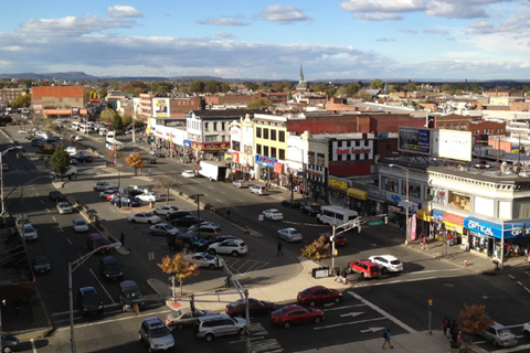 The biggest collaboration with the NJTPA and Passaic County has been the Main Avenue Local Concept Development Study. The study focused on improving safety for all road users, traffic operations, transit access, and providing support for economic development along Main Avenue between Monroe Street and Gregory Avenue.
Transportation improvements such as speed bumps, stop signs, crosswalks, flashing signs and public transit options can help alleviate traffic congestion in and around redeveloped areas, according to Lora. Not only do these efforts improve the movement of people and goods, they enhance the livability of the area, making it more attractive for redevelopment, he added.
“When people feel safe on the roads, sidewalks, and public transportation, they are more likely to choose active modes of transportation, like walking and cycling,” Lora said. Improved transportation can act as a catalyst for attracting investment and redevelopment areas, businesses are more likely more like to expand within areas with efficient transportation systems. “I would much rather have red tape cut than yellow caution tape because a child was hit,” Lora said.
NJTPA Board Chair John W. Bartlett said as Lora was speaking, he was recalling the various state and federal grant programs that helped Passaic make the many improvements.
“I was struck in your remarks that every entity on this board had touched that in some way,” Bartlett, a Passaic County Commissioner said. “It really is the practical impact of what we do around this table.”
Highlights of the Mayor Lora's presentation are in this video. A recording of the July 10 meeting is available here.