November 2023
Posted: 11/17/2023 11:52:33 AM
 New Jersey is the sixth-fastest warming state in the country, with recent summer temperatures ranked as the third hottest on record since 1895. The Garden State is warming faster than the Northeast region, seeing an increase of 3.5 degrees in the observed temperature, compared with 1.5 degrees globally, in the last 120 years.
Those are some of the stark statistics from Nathaly Agosto Filión, deputy chief climate resilience officer in the state Department of Environmental Protection’s Office of Climate Resilience, during her presentation to the NJTPA Board of Trustees meeting on November 13.
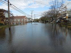 Hurricane Sandy in 2012 “is really the moment in the history of our state where we started to become much more intentional in talking about climate impacts,” Filión said. It was also a time when federal mandates to address and prevent climate impacts were increasing.
The state’s efforts culminated in 2019 when Gov. Phil Murphy signed Executive Order (EO) No. 89 establishing a statewide climate change resilience strategy. The EO created the position of state chief resilience officer, a climate and flood resilience program, and an interagency council on climate resiliency.
Filión is responsible for staffing and facilitating the work of the council which started with 17 agencies and now has 22 involved. The goal is to build resilient and healthy communities and protect the state’s ecosystem, among other priorities.
Based on the framework provided by the Governor’s EO, the NJDEP is preparing to release a Resilience Action Plan this coming spring focusing on extreme heat and steps to address it statewide – a number of which are already underway.
Among the tools available for resilience planning are:
- The New Jersey Flood Mapper allows users to zoom into their communities to see how they would be impacted in various scenarios, including sea level rise of 1-, 3- and 5- feet.
- The New Jersey Extreme Precipitation Project Tool provides users with an interactive map to identify regional and local estimates of projected changes in extreme rainfall under different scenarios.
- The Land Surface Temperature map shows surface temperature captured by satellite as proxy for heat.
Both Sustainable Jersey and Rutgers University have built upon the temperature tool, overlaying it with more information and data going down to the Census tract level, she said.
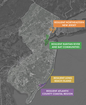
To assist in implementing resilient strategies, NJDEP created Resilient NJ, an assistance program to support local and regional climate resilience planning. Ongoing initiatives of Resilient NJ include a regional planning program across four regions (Northeastern New Jersey; Raritan River & Bay Communities; Long Beach Island; and, Atlantic County Coastal Region), a municipal assistance program in five municipalities, and another 15 more planned in 2024; and, an online toolkit for municipalities to conduct resilience planning on their own.
Using the tools, each region performs a Regional Risk Assessment on the impacts to critical facilities and assets based on future expected climate conditions. Looking at what would happen if a Sandy-like storm hit the state in 2070, the four regions would likely see some $45 billion in damages. By comparison, the entire state suffered $30 billion in damages after Hurricane Sandy, Filión said.
A recording of the presentation is
here.
Posted: 11/3/2023 9:32:08 AM
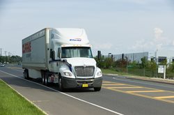
Millions of square feet of warehouse and logistics facilities have been created in the region over the past decade, leading to truck traffic and truck parking issues in and around residential areas.
Presentations during the NJTPA’s Freight Initiatives Committee meeting on Oct. 16 provided different examples of how local agencies are trying to address truck staging and parking at industrial properties.
 The first speaker was Brian Hite, transportation planner with the Lehigh Valley Planning Commission (LVPC). Truck parking is a national problem that is evident across the Lehigh Valley and the U.S., Hite said. “As the pressures of large-scale freight developers were coming in at a record pace, our municipalities needed stronger recommendations from the county-level review process,” he said. “We were determined to use the tools they had available through local ordinances and regulations.”
Through the land development process, LVPC has emphasized the need to integrate overnight or long-term truck parking on site. LVPC has been strongly recommending several appropriately sized spaces — approximately 70 feet — be provided on site so drivers have adesignated place to rest before they forced to park in inappropriate areas, like the side of a highway, to comply with federal limits on driving time.
Hite said by providing adequate parking on site, freight-centric facilities can be part of the overall mitigation of the truck parking crisis.
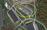 He presented an example of a truck parking courtyard at one facility, featuring 70 truck parking spaces in the center of a logistics and warehouse business. It’s good planning because it separates passenger vehicles from tractor-trailers, he said, and integrates amenities like electrical hookups, which limit tractor-trailer idling, reduces emissions, and mitigates sound impacts to adjacent properties.
Communities outside the LVPC region, including some in Connecticut and Colorado, have used the agency’s guidance documents created for their 62 municipalities.
The next speaker, Ben Spinelli, executive director of the New Jersey Highlands Council, agreed that solutions to truck parking are needed. The New Jersey Highlands Council is a regional planning agency that works with towns and counties to encourage a comprehensive regional approach to the 2004 Highlands Water Protecting and Planning Act. This includes managing a conservation zone and protection zone to minimize the loss of farmland and avoid environmental impacts.
“We’ve recognized there are places within the Highlands that can accommodate warehouses and truck parking facilities, and have tried to give appropriate guidance on where they should or shouldn’t go,” Spinelil said.
The bulk of local roadways roads in the Highlands are small two-lane roads, that can’t handle increased truck traffic, he said. Ideally, developments should be clustered into nodes, near highways where common infrastructure can be shared. “A truck courtyard goes right into what our guidelines recommend,” Spinelli said.
The final speaker, Andrew J. Lappitt, principal planner with the Middlesex County Department of Transportation presented some findings and recommendations from the recently completed Southern Middlesex County Freight Movement Study, part of the NJTPA’s Subregional Studies Program.
 With input from towns in the area, the public and facility operators, the study, he said, developed a number of recommendations to better manage truck traffic including parking needs. Parking recommendations include establishing limited-service short-term parking lots for trucks arriving early for appointments and longer-term overnight parking lots with amenities and electric charging for trucks where the driver’s daily hours-of-service time has expired. For more details on the study, click here.
“Smart logistics and warehousing people know that without trucks they don’t have a sustainable business model,” Hite said. “Incrementally, we can change the conversation from no warehouses and no trucks to siting these in appropriate locations and giving them properly located buildings to help our society function as well as succeed.”
A recording of the meeting is available here.