NJTPA Update Blog
Posted: 4/23/2024 3:25:27 PM
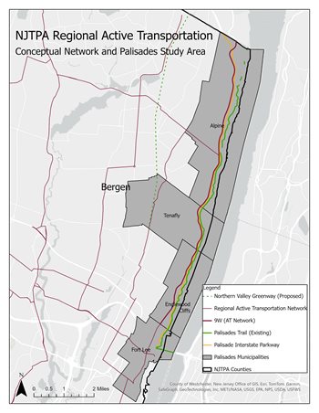
A study examining the feasibility of a 20-mile path for bicyclists and pedestrians connecting two of the largest bridges in the region is expected to be completed within the year.
 Lois Goldman, Director of Long Range Transportation Planning at the NJTPA, presented an update on the Palisades Shared Use Path Study to the NJTPA’s Project Prioritization and Planning and Economic Development committees during their April 15 joint meeting. The study led by the New York Metropolitan Transportation Council (NYMTC) is examining the potential for creating a path on the west side of the Hudson River between the Gov. Mario M. Cuomo Bridge, formerly the Tappan Zee, in Rockland County and the George Washington Bridge (GWB) in Fort Lee. NYMTC is the Metropolitan Planning Organization for New York City as well as Putnam, Rockland, and Westchester Counties. The NJTPA is assisting with the study.
The impetus for the study was the renovation last year of the GWB pathway for bicyclists and pedestrians. There’s always been a lot of cyclists particularly on the west side of the Hudson, up Route 9W and into New York, Goldman said. The idea is to look at some potential alignments, particularly some of the physical and topographical challenges as it can be very steep along the Palisades.
The study area is divided into five distinct segments, four of which are in New Jersey:
- Fort Lee
- Englewood Cliffs
- Alpine Lookout
- Borough of Alpine
- Rockland County
The study is looking at segments individually as well as together to come up with some options, Goldman said. The potential path is closely aligned with the NJTPA’s
Active Transportation Plan completed last June, which lays out a conceptual network of what a bicycle network would look like in the NJTPA’s 13-county region.
Three visioning workshops held virtually in March drew more attendance from residents of New York than New Jersey, according to Goldman. Bergen County serves on the study’s Advisory Committee and 14 towns along the route have been invited to serve on the committee. “We want to make sure communities in New York and in New Jersey are on board with this study," she said.
Union County Commissioner Bette Jane Kowalski, Vice Chair of the Planning and Economic Development Committee, asked if there would be separate paths for people walking and biking.
“It’s a shared use path but we don’t preclude anything at this point in terms of what that might be in the future; the objective is a shared use path," Gerry Bogacz, NYMTC’s Assistant Director of Planning and Program Management, said. “Safety is a big part of this, so clearly any type of separation between the modes is something we will look at, no question.”
A draft study report with findings and draft recommendations is expected by fall, when additional public meetings will be held. A final report is slated for completion by winter 2025. For additional information, visit
www.palisadespathstudy.com.
Posted: 4/22/2024 10:56:13 AM
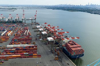
After the bridge collapse in Baltimore, about 65 percent of the containers heading to that city’s port have been diverted to the Port of New York and New Jersey, which has the capacity to help handle that cargo as well as expected future growth.
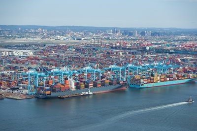 Those were among the insights offered in the annual port industry update at NJTPA’s Freight Initiatives Commitee (FIC) meeting on April 15. The presenters were Beth Rooney, Port Director for the Port Authority of New York and New Jersey, and John Nardi, President of the Shipping Association of New York and New Jersey.
The Port of New York and New Jersey is the second busiest in the United States, in cargo volume. According to Rooney, that volume surged by 28 percent over 2019 levels during the pandemic, severely straining the port’s capacity. During the past year the growth has moderated to a level 4.4 percent higher than pre-pandemic volumes in 2019. Port traffic also includes 3.1 million metric tons of bulk cargo, more than 1 million cruise passengers, and 367,000 automobiles.
Response to Baltimore
In response to the Francis Scott Key Bridge collapse in Baltimore late last month, Port Newark added additional hours and Saturday gates to handle the increase in containers. There’s “more than enough capacity” at the port to address Baltimore’s needs, Rooney said, noting that the ships were already stopping in New Jersey, they’re just offloading more cargo here now.
To date, the port has issued credentials for about 450 Baltimore truckers now coming to its facilities to pick up cargo originally destined for Baltimore. Norfolk Southern and CSX also have added shuttle trains to move cargo between the ports.
The port is committed to receiving a third of the automobiles that otherwise would have gone to Baltimore, the nation’s largest port for processing cars and trucks. Many of the diverted vehicles are being trucked on car-carriers back to Baltimore for processing, helping sustain that port’s labor force, she said.
From Shortage to Surplus
“We’re in a very unusual situation for this port,” Nardi said, after the “volume pendulum” swung last year from record cargo volumes to a sharp decline. “We quickly went from daily [labor] shortages and a burned-out workforce to having a surplus of longshoremen,” he said, as many as 400 a day.
 This year, the association has shifted focus to worker retention recognizing that its pool of trained and experienced workers cannot be easily replaced. It has turned to spending $10 to $15 million training all workers, whether actively working or not, on specialized machinery.
“It looks like ‘Star Wars’ with the type of machinery people are operating,” Nardi said. There were 825 new certifications for handling the equipment in 2023 and 2,130 recertifications. Almost 2,000 workers were trained or retrained. If normal growth occurs, Nardi suggested these workers should find a permanent home or sustainable income in a couple of years.
All the while his association, as part of the Council on Port Performance, is conducting outreach and working with area schools to secure workers for future labor needs at the port.
Lessons Learned
Asked whether there was a silver-lining for the freight industry going through the pandemic, Nardi said, “I feel like we graduated from the pandemic school. … We got a tremendous lesson in in what needs to change going forward.” This includes the need to find the right incentives to create 24/7 operations, which the industry has begun to pursue.
Rooney said during the surge of freight following the pandemic, the port was straining against its limits, handling volumes not expected until 2030. “But we handled it well and we didn't have the backups that you saw at other ports.” This gave increased confidence to shipping companies that the New York-New Jersey port can handle their needs, even in the face of disruptions and the need for new supply chains, she said.
A recording of the FIC meeting and the presentation slides are available here.
Posted: 4/11/2024 2:58:16 PM
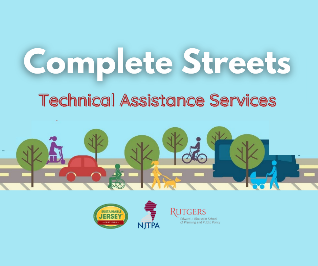 Five municipalities have been selected through a competitive application process to participate in the NJTPA’s Complete Streets Technical Assistance Program.
Belmar, Paterson, Readington and Verona will conduct complete street corridor assessments, while Belleville will develop a bicycle corridor plan. The program will assist the municipalities in documenting existing conditions, exploring potential improvements, and developing recommendations to make it safer for people walking and/or biking in the study areas. (See project summaries below).
“Complete Streets help make our roads safer for everyone, especially people walking and biking,” said NJTPA Chair John P. Kelly, an Ocean County Commissioner. “They also help create more equitable and healthy communities by giving people more options when travelling. This program helps municipalities advance their Complete Streets goals.”
The NJTPA funds this program and provides technical assistance in partnership with the Alan M. Voorhees Transportation Center at Rutgers University and Sustainable Jersey. The Complete Streets Technical Assistance Program helps municipalities bring together key stakeholders to explore a local safety concern and develop concepts for potential solutions using a collaborative approach.
“It is valuable for municipalities to receive hands-on guidance to move their Complete Streets projects forward. Complete and Green Streets have numerous safety, environmental, equity and health benefits,” said Randall Solomon, Executive Director of Sustainable Jersey. “This work is an important element in the comprehensive sustainability programs of our communities and contributes to our mission to create a more sustainable New Jersey."
Complete Streets balance the needs of drivers, pedestrians, bicyclists, transit riders, emergency responders, goods movement and stormwater management based on the local context. They help improve health and safety for people walking and biking and create better places to live, work, play, learn, and do business. When streets are not complete, the negative impacts on public health, safety, equity, the economy, and the environment are disproportionately borne by low-income and minority communities.
Improving safety is a key goal of this program.
“Across New Jersey and the broader nation, we’ve seen a troubling rise in roadway fatalities, particularly among pedestrians and cyclists,” said Jon A. Carnegie, Executive Director of the Alan M. Voorhees Transportation Center. “The recommendations that are developed through these projects will help communities enhance the safety of their roadways for all users,”
This is the fourth time the NJTPA has offered technical assistance to municipalities in its region. Learn more at njtpa.org/completestreets.
Summaries of the five selected projects are as follows:
Belleville Township — A bicycle corridor plan will primarily focus on Division Avenue from Union Avenue to Passaic Street, a wide road that experiences congestion, especially during school drop-off and pick-up. Vehicle speeding is also a concern in the area. This effort will explore the possibility of adding a bicycle lane to the corridor and is expected to include a pop-up demonstration to illustrate to community members what that could look like.
Belmar Borough — A Complete Streets corridor assessment will focus on a half-mile stretch of 8th Avenue from the beach to near Silver Lake. This busy road connects residents to important services and serves tourists during the busy summer season. This effort will explore ways to improve safety for all travelers, but especially those walking and biking.
Paterson City — A Complete Streets corridor assessment will focus on McBride Avenue from Paterson Great Falls National Historic Park at Wayne Avenue to the pedestrian bridge at Rockland Street. The assessment will explore ways to provide direct pedestrian access to Westside Park and improve pedestrian safety along the busy corridor.
Readington Township — A Complete Streets corridor assessment will focus on Main Street (County Route 523) from the Whitehouse Train Station to just south of Route 22. The study area is the most densely populated portion of the Township and experiences high vehicular traffic. With housing, the train station, the municipal building, and parks along the county road, many residents walk in this area. This assessment will explore ways to improve safety along this busy corridor.
Verona Township — A Complete Streets corridor assessment will focus on Linden Avenue from Fairview Avenue to Wildwood Terrace. This corridor is near several public schools as well as the Bloomfield Avenue town center. Pedestrians, cyclists, and motorists traverse Linden Avenue to access these various destinations. Speeding is a concern along Linden Avenue, particularly with the number of students using the road to walk to school. This assessment will explore ways to make the road safer, particularly for pedestrians and cyclists.
Posted: 3/18/2024 11:05:35 AM
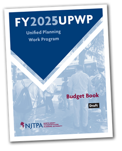 The NJTPA Board of Trustees approved a work program for the next fiscal year, which includes updating the Long Range Transportation Plan (LRTP), and launching three new pilot programs.
The Fiscal Year 2025 Unified Planning Work Program, which begins July 1, details the work of NJTPA’s Central Staff, its member agencies and the state’s eight transportation management associations.
The LRTP is one of the agency’s core documents. It sets a vision for the region’s transportation future and guides the NJTPA’s work. The Board is set to adopt the plan in September 2025. In tandem with this, Central Staff will also work to update the Transportation Improvement Program, or TIP, which is a four-year list of federally funded projects included in the LRTP. Staff will also lead a consultant effort to estimate the emissions impact of these projects, to ensure they do not have a negative impact on the region’s air quality. This is called the Air Quality Conformity Determination. This determination and the TIP will also go to the Board for consideration in September 2025.
The work program includes several new pilot programs:
- Complete Streets Conceptualization: This effort will provide consultant-supported planning and project development assistance to advance a local Complete Streets project that addresses community and regional goals regarding safety, accessibility, equitable access to employment and other destinations, access to public transportation, and reduction of single-occupancy vehicle trips. This study will also develop guidelines for a Complete Streets Conceptualization Program including project identification, prioritization and selection, the specific steps to complete the process, and final deliverables.
- Pedestrian Lighting Analysis: This effort will examine up to 26 locations across the NJTPA region. While only 25 percent of vehicle miles travelled occur at night, the nighttime pedestrian fatality rate is three times higher than during the day. Recommendations will be developed to improve lighting and pedestrian safety at each location. The reports prepared for each location can be used to advance projects through the NJTPA’s Local Safety Program.
- Intersection Control Evaluation: This effort was recommended in New Jersey’s last Strategic Highway Safety Plan update. It will help develop a performance-based approach for screening alternatives and identifying optimal geometric and traffic control solutions for high-crash intersections. Staff will work with the NJTPA subregions to select 15 locations for evaluation.
The work program also includes two Freight Concept Development studies, Southern Middlesex County North-South Truck Corridor Project in Cranbury and Monroe, Middlesex County; and Hanover Avenue Bridge Catenary Rail Clearance Project in Morris Plains, Morris County.
Several initiatives that began in FY 2024 will conclude in the next fiscal year, including the completion of Local Safety Action Plans for eight counties in the NJTPA region; a consultant-led effort to gather public input for the LRTP; demographics and travel analysis, and freight industry forecasts, which will be used for the LRTP update.
Posted: 3/15/2024 2:53:53 PM
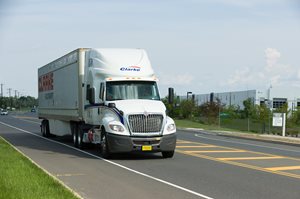
 Two projects selected for the NJTPA’s next Freight Concept Development Program (FCDP) would address truck traffic in Southern Middlesex County and a bridge clearance issue in Morris County to allow more taller, industry standard freight trains to serve the area.
The NJTPA Board of Trustees approved up to $1.5 million in funding for the two Freight Concept Development Program Studies during its meeting March 11 following approval by the Project Prioritization Committee in February. The funding will commence in Fiscal Year 2025(which begins July 1, 2024). The two projects are:
Southern Middlesex County North-South Truck Corridor Project, Cranbury and Monroe, Middlesex County
This project advances the recommendation from the Southern Middlesex County Freight Movement Study, completed in June 2023 through the NJTPA’s Subregional Studies Program, to create a north-south truck corridor to mitigate the number of trucks traveling in residential areas.
 The current roadway network can cause trucks to travel on County Route 619 (Applegarth Road) or create confusion about the appropriate truck route, leading to trucks traveling into residential neighborhoods. Among the measures, recommended in the study are applying to the New Jersey Department of Transportation for truck restrictions on key local roads; installing new wayfinding signage for trucks; reconfiguring intersections to better accommodate truck movements, and reducing the speed limit on state Route 32 and standardizing the number of lanes in each direction. According to the study, Route 32 is considered a “truck crash hotspot.” The new truck route would be mostly parallel to the New Jersey Turnpike and County Route 619. It would add capacity and accommodate north-south traffic through Cranbury and Monroe.
Hanover Avenue Bridge Catenary Rail Clearance Project, Morris Plains, Morris County
This project advances a recommendation from the 2013 Morris/Warren County Rail Corridor Study to explore alternatives for eliminating the rail clearance issue below the Hanover Avenue Bridge. Freight railroads use NJ TRANSIT’s Morristown Line, which has overhead catenary below the bridge that limits the height of rail cars that pass underneath. Once completed, the project will open the entire corridor from Phillipsburg to Morristown for taller, industry standard freight rail cars to travel and serve customers along the main line and several branch lines within Morris County.
More than 1,000 potential freight projects have been identified over the past decade in planning studies conducted in the NJTPA region, many of which do not have a clear path forward toward implementation. The NJTPA’s Freight Initiatives Committee in 2018 approved creating the Freight Concept Development Program, which included a process to identify and select projects to advance. The two projects were selected from among 27 candidate projects.
Posted: 3/13/2024 1:59:25 PM
Halfway through the five-year Infrastructure Investment and Jobs Act (IIJA), Erich Zimmermann laid out the challenges and changes ahead for reauthorization of the $1.2-trillion program to the NJTPA Board of Trustees.
Zimmermann, executive director of the National Association of Regional Councils (NARC), spoke before the Board during its bi-monthly meeting on March 11. The Washington, D.C.-based member organization includes regional councils, councils of governments (COGs), regional planning and development agencies, and metropolitan planning organizations (MPOs), and advocates for regional cooperation to address planning and development.
 “The tide in D.C. is starting to turn already, from focus on implementation to reauthorization," he said, noting that May 2024 is the halfway mark of the IIJA. “We’re facing a more interesting reauthorization than we usually do.”
The sheer size of the bill “makes it a different beast when we’re typically just talking about transportation,” he said, as the breadth of the program extends well beyond transportation. There will be big questions about which pieces of the IIJA are going to be preserved and which might be forgone.
Going forward, Zimmermann suggested shifting some discretionary programs into formula programs. “We're big proponents of formula funding, where money goes out and everybody across the nation gets some funding for whatever particular program,” he said.
While there are worthy discretionary grant programs, there are some challenges that come with those grants, including expensive and cumbersome application processes, he said. "At the end of the day, when you have an expensive application process, communities that are less resourced are going to have a harder time succeeding,” he said.
 He held up Safe Streets and Roads For All as an example of a discretionary grant that could become a formula program, where funding goes directly to local entities to meet safety needs. “We need to continue to not only bolster that but expand it, so everyone’s getting a piece of that pie, not just those that are able to get through the discretionary grant process,” Zimmermann said.
“One thing we're going to need to do to show Congress we can support robust programs going forward is really accentuating the wins that came out of IIJA and that will continue to come out of this program.”
A recording of the March 11 Board of Trustees meeting can be accessed here.
Posted: 3/12/2024 8:56:27 AM
 Ocean County Commissioner John P. Kelly told fellow Board members that as NJTPA Chair, improving safety and accessibility along Route 9, one of the region’s most congested corridors will be his top priority.
“Our infrastructure needs to ensure that people can get to where they need to go safely and efficiently, regardless of their travel mode,” he said at the March 11 Board of Trustees meeting. “Reducing this congestion will also help improve air quality for residents in the communities along Route 9.”
The Board elected a new Executive Committee, including naming Commissioner Kelly Chair, at its January meeting.
Chairman Kelly noted that in addition to improving the flow of vehicles along Route 9, it’s important to also consider upgrades to make it safer for pedestrians and cyclists, particularly in Lakewood. He said he looks forward to working with the New Jersey Department of Transportation to explore solutions for the corridor. He noted that the NJTPA completed a study in 2016 that explored potential improvements to Route 9 in Lakewood and Toms River.
Improving safety, accessibility and air quality, and reducing congestion — all things Kelly said he would like to see accomplished for Route 9 — are among the NJTPA’s goals in its Long Range Transportation Plan. The NJTPA will be launching an update of that plan, which guides all its planning work, later this year, including extensive outreach to Board members, stakeholders, and the public.
Another key-theme in the long-range plan is resiliency, and Kelly said that is also an area he would like to focus on, noting that Route 9 is a critical evacuation route during natural disasters, such as hurricanes and forest fires.
“It’s critical that we harden our region’s infrastructure to withstand extreme weather events,” he said. “While this is particularly important in a coastal county like Ocean, it is increasingly an issue throughout our entire region.”
Posted: 3/7/2024 12:47:47 PM
 A partnership of agencies in the greater New York-New Jersey metropolitan area, including the NJTPA, submitted a Priority Climate Action Plan (PCAP) on March 1 as part of a multi-year grant to reduce greenhouse gas emissions (GHG) and other harmful air pollution in the region.
The PCAP is the initial step in fullfilling the terms of the Environmental Protection Agency’s (EPA) Climate Reduction Grant (CPRG), awarded in September. It includes a GHG inventory, emissions projections, proposed reduction measures, and an analysis of how the measures could benefit low-income and disadvantaged communities.
The plan identifies nine priority GHG reduction measures, aimed at addressing the largest sources of emissions in the region. These measures include:
- Zero emission passenger vehicle adoption
- Zero emission bus and truck adoption
- Alternative freight modes
- Travel demand management and reduction of VMT
- Maritime and air travel emissions
- Building electrification and energy efficiency
- Grid decarbonization
- Waste disposal reduction
- Additional cross-cutting measures
The next step will be to create a Comprehensive Climate Action Plan (CCAP) which is due in September 2025, two years from the date of the grant award. The comprehensive plan will include additional research, analysis, stakeholder engagement and community outreach to further develop measures that will help the region meet its emissions goals.
The CPRG is a nationwide grant program funded by the Inflation Reduction Act. The first phase provided $250 million in noncompetitive planning grants to states and other entities to develop both the PCAPs and CCAPs. With a PCAP in place, the states, counties and municipalities in the region can apply for $4.6 billion in competitive grants to implement priority measures. The deadline to apply for implementation grants is April 1.
To view the PCAP and learn more, visit bit.ly/NYNJClimatePlan
Posted: 2/26/2024 1:07:37 PM
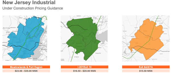
The industrial real estate market is settling into a new normal after a frenetic few years, with construction of new facilities tapering off yet rents continuing to rise.
Bill Waxman, vice chair, Cushman and Wakefield, and Eric M. Bernstein of Eric M. Bernstein and Associates, LLC, served as panelists for the annual regional industrial real estate update during the NJTPA's Freight Initiatives Committee (FIC) meeting on Feb. 20.
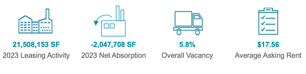 The boom in warehouse construction had been driven by the need for companies to meet strong consumer demand for goods, particularly in the pandemic when consumers turned to online shopping in a big way. That construction is beginning to taper off, according to Waxman. He expects new construction starts will continue to decline this year. The 5.8 percent vacancy rate is still well below the 10-year average of 8 percent.
The market recorded “negative absorption” – supply of building space outstripping demand for it – due to a record 14.4 million square feet of new buildings delivered that all became available at once. The shift began at the start of 2023 after a decade of positive absorption, Waxman said.
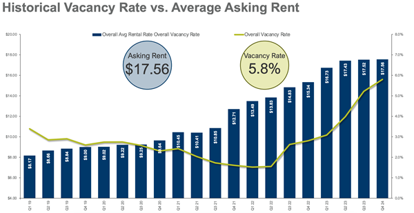 Yet rents continue to grow even though vacancy also grows - “It defies logic,” Waxman said. That’s because many renters are downsizing from non-Class A buildings -- older industrial facilities located in poor markets and elsewhere -- in favor of smaller spaces in more modern Class A buildings which are commanding higher rents. Many of the newer buildings are in the south and western areas of the region.
“They may be vacating 200,000 square feet of several older buildings and moving into one, more efficient building further south or where buildings are less expensive, so they’re absorbing 150,000 of new Class A building but leaving 200,000 square feet of older, industrial product on the market,” he said. “That’s why 100 percent of that negative absorption was in B and C buildings and positive absorption was all within Class A.
Companies traditionally in Linden, Elizabeth, and Edison are saying, “I don’t need to be there,” and decamping for cheaper rents in areas like Hamilton, Somerset, and Parsippany, according to Waxman. “That’s one of the reasons why you’ll see Class A continue to be strong,” he said, with more efficient buildings and a flight to quality continuing.
The ability to build new buildings in New Jersey, however, is becoming much more difficult. “A lot of towns are saying we have enough, we don’t want more warehouses," Waxman said. “Demand is falling so builders are waiting and not going to spec a building."
Bernstein thinks the slowdown in buildings is a good thing. Before COVID, he said most developers wanted nothing to do with warehouses.
 “In the old days, when you built a strip mall, you had some idea what kind of clientele you were seeking,” Bernstein said. Now, when an applicant is asked what sort of warehouse they will build, they won’t commit, despite 13 categories to choose from. The answer typically is: “It won’t be a fulfillment center.” This lack of detail leaves town officials in the dark about potential impacts and has led to increasing resistance to the facilities.
If developers adequately planned ahead they could explain the pros and cons of the category of facility that they were seeking. But that is not occurring.
“You can’t get what seemingly is a reasonable answer," Bernstein said.
The presentations and a complete recording of the FIC meeting are available here.
Posted: 2/21/2024 1:31:37 PM
A new online tool available from the NJTPA will give municipalities and other agencies access to detailed travel data for hundreds of locations, helping them conduct feasibility studies for projects to improve safety and address traffic problems.
The Vulnerable User (VU) and Vehicle Traffic Counts Viewer is an online database of traffic counts collected by the NJTPA available for public access.
Aimee Jefferson, Principal Planner, Safety Programs in Local Project Development, at the NJTPA, provided a demonstration of the new tool during the Regional Transportation Advisory Committee’s Feb. 13 meeting.
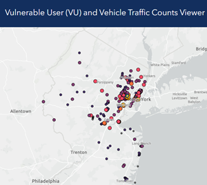 The focus is on vulnerable users, like pedestrians, cyclists, and micromobility users, though many vehicle-focused counts are also available, according to Jefferson. The viewer primarily has been used to conduct Level Of Service (LOS) evaluations for Local Safety Programs and other highway safety and manual analysis.
Municipalities and other agencies can use it where high counts would help determine whether facilities are feasible, such as:
- Road diet feasibility studies
- Traffic signal warrant analysis
- Bike lanes and improved crosswalks
The database is one of the recommendations from a two-year effort by NJTPA in 2020 to collect traffic counts with a focus on collecting pedestrian, bicycle, and micromobility counts, as well as vehicular counts, and developing count standards and recommendations.
In New Jersey, the
Delaware Valley Regional Planning Commission (DVRPC) and Department of Transportation (DOT) also publish traffic count data, Jefferson said. DVRPC only collects counts for its region and DOT's online database only has vehicular counts.
The VU tool currently has more than 400 locations and three data types with bicycle, pedestrian, micromobility and vehicular volumes. Data includes counts collected during NJTPA projects as well as any counts subregional partners have shared with NJTPA. “As count data becomes more robust, more detailed modeling and forecasting of bike, pedestrian, and micromobility volumes may also be available and possible,” she said. New locations are added on a rolling basis.
A table function allows users to export datasets and a glossary breaks down technical language and provides sources of the data and potential use cases.