 The NJTPA just released an Active Transportation Plan to provide a blueprint for creating a “safe, comfortable, and connected network” for walking and biking in the northern and central New Jersey region. This plan was crafted against the backdrop of a growing interest in walking and biking that emerged during the COVID lockdown in 2020. The plan is posted here.
The Active Transportation Plan aims to connect people and places in an environmentally sustainable way. The plan aligns with other NJTPA programs, such as promoting complete streets, transit oriented development, and multimodal safety. The plan was the subject of a presentation by NJTPA staff planner Keith Hamas at the NJTPA Joint Committee meeting on August 28 (a video of the presentation is here).
The plan revolves around several key principles:
- Safety: emphasizing the need to reduce bike and pedestrian crashes
- Connectivity: to create reliable walking and biking routes
- Opportunity: ensuring equitable access to non-motorized transportation options, particularly for underserved populations
- Participation: encouraging more people to regularly bike and walk
- Engagement: to gather the perspectives of traditionally underrepresented groups
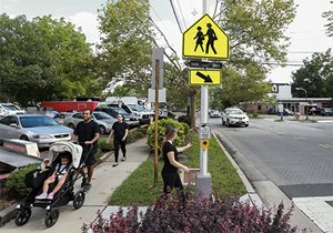
The public engagement process for developing the plan included a mix of pop-up events, where the project team facilitated discussion and participation in an online survey and web map. These public input tools helped create an understanding of people’s preferences and the challenges they face with walking and biking. “Whether in urban, suburban or rural areas,” the plan finds, “most residents are seeking more opportunities to walk and bike, whether for commuting, for health, or for fun.”
To expand opportunities, the plan identifies a conceptual regional network consisting of more than 1,700 miles of roadways recommended for walking and biking improvements across North Jersey. More than 5.6 million people live within one mile of the network. The plan maps a half-mile buffer along roadways to assist in identifying possible low-stress alternatives to high-demand, high-stress routes.
Additionally, the plan includes a strategy guide to help cities and towns implement the recommendations. This guide outlines actions and strategies in various categories like capacity building, coordination, data collection, equity, funding, and community engagement.
The plan also offers two case studies, focusing on Parish Drive in Wayne Township and Main Street in the Boroughs of Stanhope and Netcong. A third case study focuses on best practices for designing active transportation infrastructure through major highway interchanges, which often present barriers and hazards along biking routes.
The NJTPA will offer ongoing support for implementing the plan recommendations including sharing data and a map viewer tool to assist counties and municipalities in prioritizing efforts.